Understanding types of clouds is essential for learning about weather patterns and climate. Clouds form in different layers of the atmosphere and have unique shapes, structures, and effects on weather conditions. In this blog post, we will learn about various cloud types, their features, and their role in weather forecasting. Learning cloud vocabulary will help in understanding weather reports and scientific discussions with ease.
Enhance your learning by exploring more Picture Vocabulary on various topics.
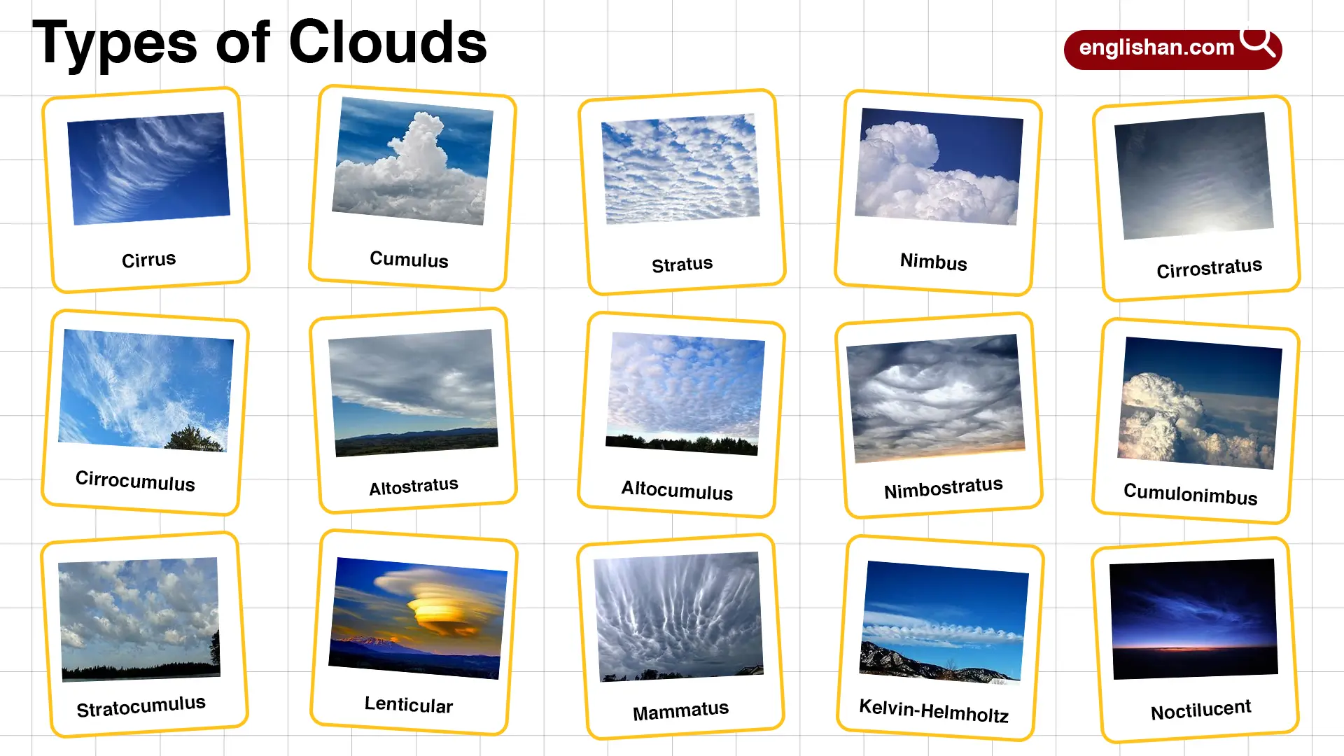
Names of Types of Clouds
High-Level Clouds
Cirrus
Cirrus clouds are thin, wispy formations found at high altitudes. They indicate fair weather but can also signal an approaching weather front. They primarily consist of ice crystals and appear in streaks across the sky.
Cirrostratus
Cirrostratus clouds form a thin, uniform veil covering the sky, often causing a halo effect around the sun or moon. These clouds indicate incoming precipitation, especially rain or snow, within 24 hours.
Cirrocumulus
Cirrocumulus clouds appear as small, rippled patches in the sky, resembling fish scales. They indicate cold, fair weather but may precede storm development.
Mid-Level Clouds
Altostratus
Altostratus clouds are gray or blue-gray sheets that cover the sky. They often precede continuous rain or snow, blocking sunlight partially or completely.
Altocumulus
Altocumulus clouds are white or gray masses appearing in wavy bands. They usually indicate fair weather, but their presence in humid conditions can suggest potential thunderstorms.
Low-Level Clouds
Stratus
Stratus clouds are thick, low-hanging clouds that cover the sky in a uniform gray layer. They bring overcast conditions, drizzle, or light rain.
Stratocumulus
Stratocumulus clouds are low, lumpy clouds that appear in groups. They usually bring dry, mild weather but may produce light rain in some cases.
Nimbostratus
Nimbostratus clouds are dark, thick clouds that bring continuous rain or snow. They block sunlight completely and are responsible for steady precipitation over long periods.
Vertical Clouds
Cumulus
Cumulus clouds are fluffy, white clouds with flat bases and puffy tops. They indicate fair weather but can develop into larger storm clouds.
Cumulonimbus
Cumulonimbus clouds are towering clouds associated with thunderstorms, heavy rain, lightning, and tornadoes. They can reach high altitudes and extend across different cloud layers.
Special Cloud Formations
Lenticular
Lenticular clouds form in lens-like shapes over mountains or hills. They appear smooth and can resemble flying saucers. They usually indicate stable air conditions.
Mammatus
Mammatus clouds have a pouch-like structure hanging from the base of larger clouds. They form during severe storms and indicate unstable atmospheric conditions.
Kelvin-Helmholtz
Kelvin-Helmholtz clouds resemble ocean waves and form due to wind shear between different air layers. They indicate turbulence and are often short-lived.
Noctilucent
Noctilucent clouds appear at very high altitudes during twilight. They glow in shades of blue and are composed of ice crystals and meteor dust.
Pyrocumulus
Pyrocumulus clouds form due to intense heat from wildfires, volcanic eruptions, or industrial activity. They can grow into storm clouds and produce localized rain.

Interesting Facts About Clouds
- The highest clouds in the Earth’s atmosphere are Noctilucent clouds, found at altitudes above 50 miles.
- Cumulonimbus clouds can grow up to 12 miles high, spanning multiple layers of the atmosphere.
- Mammatus clouds do not produce storms themselves but are indicators of severe weather conditions.
- Kelvin-Helmholtz clouds resemble breaking ocean waves due to differing wind speeds at various heights.
- Pyrocumulus clouds can lead to localized thunderstorms, even in areas without regular precipitation.
FAQs
The three main types of clouds are cumulus (fluffy), stratus (layered), and cirrus (wispy). These cloud types form at different altitudes and indicate various weather conditions.
Nimbostratus and cumulonimbus clouds are the primary rain-producing clouds. Nimbostratus clouds bring steady rain, while cumulonimbus clouds cause thunderstorms.
Noctilucent clouds are composed of ice crystals and meteor dust, forming at the highest levels of the atmosphere during twilight.
You May Also Like
